CONTINENTS:
Earth is composed of major landforms known as continents. The continents are composed of political divisions known as countries.
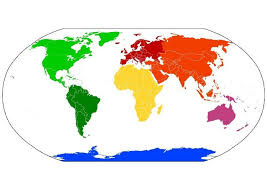
The seven continents are: North America  South America
  Europe
  Asia
Asia  Africa
  Australia
  Antarctica
OCEANS: (see www.worldatlas.com and www.enchantedlearning.com)

The planet is approximately 71% water and contains (5) five oceans, including the Arctic, Atlantic, Indian, Pacific and Southern.

For many years only (4) four oceans were officially recognized, and then in the spring of 2000, the International Hydrographic Organization established the Southern Ocean, and determined its limits. Those limits include all water below 60 degrees south, and some of it, like the Arctic Ocean, is frozen.
EQUATOR (see www.worldatlas.com )
- The equator is 0 degree latitude.
- This imaginary line runs through parts of South America, Africa, and Asia.
- It is officially the halfway point between the North Pole and the South Pole.
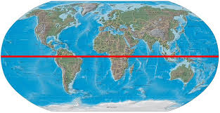
(image from http://mappery.wordpress.com/tag/equator/)
PRIME MERIDIAN
- The prime meridian is 0 degrees longitude.
- This imaginary line runs through the United Kingdom, France, Spain, western Africa, and Antarctica.

(image from http://www.reformation.org/large-prime-meridian.jpg)
HEMISPHERES:
The earth is divided into four hemispheres (the Northern, Southern, Eastern, and Western) each representing one-half of the earth.
There is a Northern Hemisphere and a Southern Hemisphere that are divided by the equator.
The earth is also divided into an Eastern Hemisphere and a Western Hemisphere which are divided by the Prime Meridian.
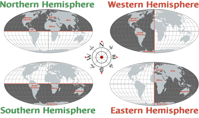
Copyrighted by Graphic Maps.
LONGITUDE AND LATITUDE
Longitude and Latitude
Here is a game from www.kidsgeo.com in which you use longitude and latitude lines to locate places on a map!

Continents and Oceans Page 2
FrontPage
)
Comments (0)
You don't have permission to comment on this page.